
A WRECK
REMADE IN
THREE DIMENSIONS.
HMT Garmo. Lost off Scarborough in December 1914. Re-imagined from a measured wreck footprint, historical records and the features described by divers.
Turn it.
Investigate it.
This is our first original interactive wreck model — made for The Wreck Explorer. It is not a scan, a measured archaeology model or a dive plan. Move around the wreck to discover what we know and where interpretation begins.
One finger rotates. Pinch to zoom. Tap a glowing marker to investigate a feature.
HMT Garmo.
The bow and anchor
The forward section remains recognisable in diver descriptions. An anchor is reported on the seabed in front of the bow.
The evidence-led
working plan.
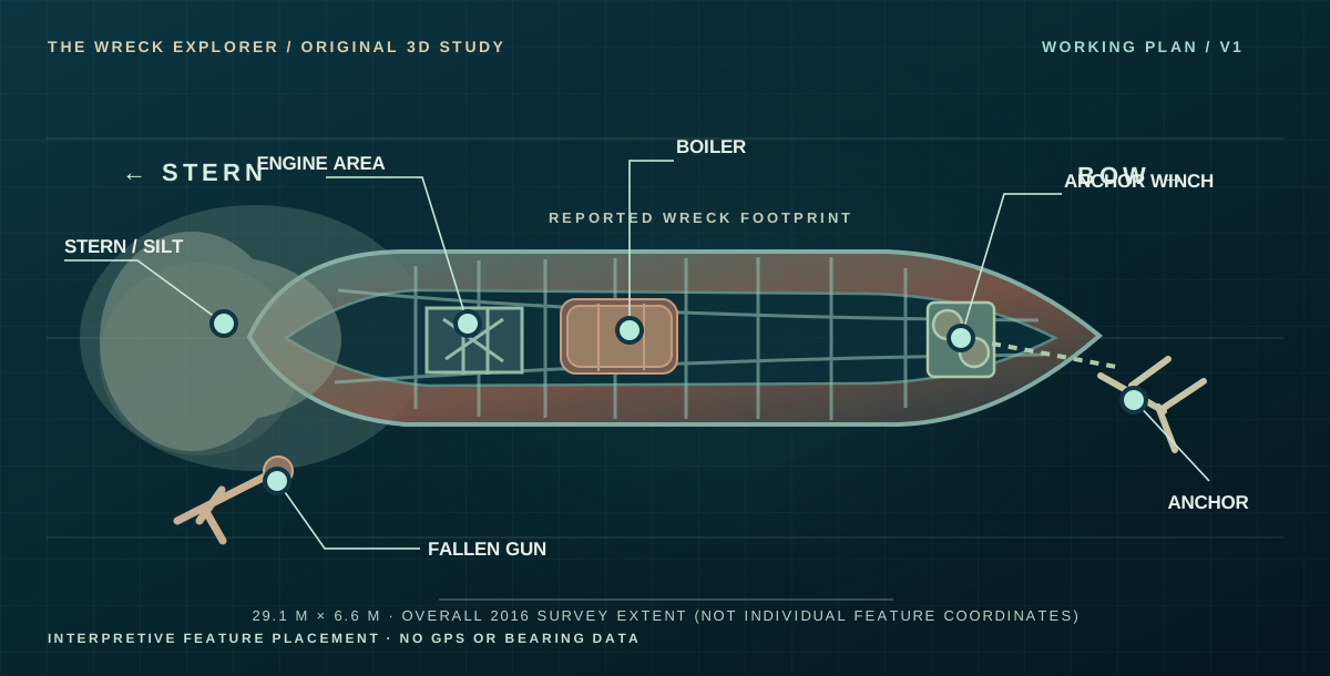
Stern to the left, bow to the right. The schematic positions match the interactive model, but are not accurate geographic bearings or surveyed positions of individual objects.
ON iPHONE: SWIPE THE PLAN LEFT OR RIGHT TO INSPECT EVERY LABEL →
Where fact ends,
we say so.
Published hydrographic notes describe an approximately 29.1 m wreck with a 6.6 m beam, a low surviving profile and partial burial. Diver accounts describe recognisable bow machinery, boiler, engine and a displaced gun.
But the identification of the site as HMT Garmo is still regarded as probable, and we do not have georeferenced photographs or a full measured feature-by-feature survey. The positions of the individual parts in our model are interpretations based on those reports.
OPEN THE HMT GARMO RESEARCH DOSSIER ↗This is not a navigational aid, a legal site assessment or a scientific reconstruction. Original wreck photographs belong to their respective credited creators.
Every new photograph
can make this better.
The model is a first working interpretation. As more authenticated diver photographs, measured sketches and sonar records become available, we can refine the hull and feature positions instead of inventing finer detail.
EXPLORE GARMO'S STORY ↗